Continuing Gaua activity at the NASA Earth Observatory 27 April 2010
Posted by admin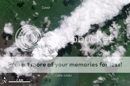
As reported here last week, activity is continuing at Gaua volcano in Vanuatu, with the government planning for evacuations of Gaua Island. The NASA Earth Observatory has been providing some excellent satellite imagery of Gaua, most recently the above image, captured on 24 April 2010 by the Advanced Land Imager aboard NASA's Earth Observing-1 (EO-1) satellite. The brown areas on the left of the image, to the west and south-west of the volcano, show where volcanic emissions and ashfall have damaged and killed vegetation.
The world is paying little attention to the activity at Gaua, but it is shaping up to be a very nasty, hazardous and disruptive eruption. Ashfall, poisonous gases, volcanic bombs and mudflows are being produced by the active cone, Mount Garet, and emissions are tainting local crops and water supplies. Rising water levels in the crater have been reported, increasing the risk of still more dangerous mudflows. The population of Gaua has already had to abandon the western side of the island and seek refuge in the east, away from the worst of the volcano's ash and fumes, but as the activity increases they may have to evacuate completely. Radio Australia News quotes Vanuatu Geohazards Technical Advisor: 'The current risk is mainly ash falls and then mudflows. It's true that we have an increase in activity but not like a level 3. Evacuation is ready the plan is ready the location is ready, it's a very tough situation for the local population of Gaua, they're scared they're afraid, it's a very new situation for them'.
The alert level for Gaua is still at level 2, according to the Vanuatu Geohazards Observatory.
http://volcanism.wordpress.com/2010/04/27/continuing-gaua-activity-at-the-nasa-earth-observatory/
====================
Geographic coordinates: 13.952S, 166.661E
Magnitude: 5.0 Mb
Depth: 35 km
Universal Time (UTC): 29 May 2010 11:47:42
Time near the Epicenter: 29 May 2010 22:47:42
Local standard time in your area: 29 May 2010 05:47:42
Location with respect to nearby cities:
183 km (114 miles) NNW (344 degrees) of Santo (Luganville), Vanuatu
=====================
SOUTHERN CALIFORNIA
Geographic coordinates: 32.717N, 115.882W
Magnitude: 3.8 Ml
Depth: 1 km
Universal Time (UTC): 29 May 2010 14:50:00
Time near the Epicenter: 29 May 2010 07:50:00
Local standard time in your area: 29 May 2010 08:50:00
Location with respect to nearby cities:
11 km (7 miles) ESE (103 degrees) of Ocotillo, CA
20 km (12 miles) WSW (245 degrees) of Seeley, CA
31 km (20 miles) WSW (255 degrees) of El Centro, CA
================
SOUTHERN GREECE
Geographic coordinates: 37.848N, 21.328E
Magnitude: 4.4 Mb
Depth: 50 km
Universal Time (UTC): 29 May 2010 19:05:14
Time near the Epicenter: 29 May 2010 22:05:14
Local standard time in your area: 29 May 2010 13:05:14
Location with respect to nearby cities:
56 km (35 miles) SW (220 degrees) of Patras, Greece
115 km (71 miles) NW (323 degrees) of Kalamata, Greece
207 km (128 miles) SSE (168 degrees) of Ioannina, Greece
212 km (132 miles) W (266 degrees) of ATHENS, Greece
==============
VANUATU
Geographic coordinates: 13.691S, 166.376E
Magnitude: 4.8 Mb
Depth: 33 km
Universal Time (UTC): 30 May 2010 01:21:30
Time near the Epicenter: 30 May 2010 12:21:30
Local standard time in your area: 29 May 2010 19:21:30
Location with respect to nearby cities:
220 km (137 miles) NNW (338 degrees) of Santo (Luganville), Vanuatu
496 km (308 miles) NNW (335 degrees) of PORT-VILA, Vanuatu
=================
BANDA SEA
Geographic coordinates: 5.327S, 123.385E
Magnitude: 4.9 Mb
Depth: 41 km
Universal Time (UTC): 30 May 2010 02:19:56
Time near the Epicenter: 30 May 2010 10:19:56
Local standard time in your area: 29 May 2010 20:19:56
Location with respect to nearby cities:
87 km (54 miles) ENE (77 degrees) of Baubau, Sulawesi, Indonesia
434 km (270 miles) E (93 degrees) of Ujung Pandang, Sulawesi, Indonesia
============
LIBERTADOR O'HIGGINS, CHILE
Geographic coordinates: 34.747S, 71.511W
Magnitude: 4.7 Mb
Depth: 35 km
Universal Time (UTC): 30 May 2010 02:27:43
Time near the Epicenter: 29 May 2010 22:27:43
Local standard time in your area: 29 May 2010 20:27:43
Location with respect to nearby cities:
81 km (50 miles) N (10 degrees) of Talca, Chile
159 km (99 miles) SSW (209 degrees) of SANTIAGO, Chile
============
SOUTHERN PERU
Geographic coordinates: 15.240S, 73.291W
Magnitude: 4.5 Mb
Depth: 102 km
Universal Time (UTC): 30 May 2010 08:48:22
Time near the Epicenter: 30 May 2010 03:48:22
Local standard time in your area: 30 May 2010 02:48:22
Location with respect to nearby cities:
105 km (65 miles) ESE (123 degrees) of Puquio, Peru
229 km (142 miles) NW (305 degrees) of Arequipa, Peru
238 km (148 miles) SW (217 degrees) of Cuzco, Peru
536 km (333 miles) SE (131 degrees) of LIMA, Peru
=============
FOX ISLANDS, ALEUTIAN ISLANDS
Geographic coordinates: 52.717N, 167.111W
Magnitude: 4.3 Mb
Depth: 14 km
Universal Time (UTC): 30 May 2010 10:06:13
Time near the Epicenter: 30 May 2010 02:06:13
Local standard time in your area: 30 May 2010 04:06:13
Location with respect to nearby cities:
120 km (75 miles) E (101 degrees) of Nikolski, AK
136 km (84 miles) SSW (197 degrees) of Unalaska, AK
181 km (112 miles) SSW (209 degrees) of Akutan, AK
==================
HINDU KUSH REGION, AFGHANISTAN
Geographic coordinates: 36.253N, 71.378E
Magnitude: 4.5 Mb
Depth: 98 km
Universal Time (UTC): 30 May 2010 13:53:51
Time near the Epicenter: 30 May 2010 18:23:51
Local standard time in your area: 30 May 2010 07:53:51
Location with respect to nearby cities:
68 km (42 miles) NW (309 degrees) of Chitral, Pakistan
119 km (74 miles) SE (142 degrees) of Feyzabad, Afghanistan
=================
Thousands flee volcanos in Ecuador and Guatemala
Thousands of people have been forced to flee their homes as two volcanos erupted in Guatemala and Ecuador.In Guatemala, the Pacaya volcano began spewing lava, rocks and debris on Thursday, killing at least two people and injuring more than 50 others.
In Ecuador, the Tungurahua volcano forced the evacuation of seven villages and shut the airport and schools in Guayaquil, the country's largest city.
There is no suggestion the upsurge in volcanic activity is related.
In Guatemala, at least 1,700 people have fled the eruption, some 30km (19 miles) south of the capital city.

President Alvaro Colom has declared a state of emergency in Escuintla region, Guatemala City and areas surrounding the capital.
He said two people had died and three children were missing.
One man was killed when he fell from a building while sweeping up the ash. A TV reporter also died while covering the eruption.
In the village of Calderas, close to the eruption, Brenda Castaneda said her family hid under furniture as molten rocks fell on her house.
"We thought we wouldn't survive. Our houses crumbled and we've lost everything," she told the Associated Press from a temporary shelter.
The volcano has covered parts of Guatemala City in ash - up to 7cm (2.7in) thick in some areas - forcing the closure of the country's main international airport.
Seismologists have warned of more eruptions "in the coming days" from Pacaya - one of the most active volcanos in Central America.
Health concernsIn Ecuador, the Tungurahua volcano sent ash plumes six miles (10km) into the air.
 Several thousand people have been evacuated near Tungurahua
 Several thousand people have evacuated their homes in the area, 95 miles (150km) south-east of the capital Quito.
Strong winds blew the ash over the country's most populous city, Guayaquil, and forced aviation officials to close the country's main airport.
Julio Castro, who lives in Guayaquil, said he was worried about the health of children.
"Suddenly, without warning, the ash started to fall, and it was heavy, some even got into my eyes," he told the Associated Press.
"I can't see well now, it is annoying and we are worried for the children, above all."
There were reports that the ash cloud was dissipating as it drifted out over the Pacific Ocean.
http://news.bbc.co.uk/2/hi/world/latin_america/10189054.stm
=====
OFF COAST OF CENTRAL AMERICA
Geographic coordinates: 12.324N, 88.490W
Magnitude: 4.9 Mb
Depth: 10 km
Universal Time (UTC): 29 May 2010 16:11:43
Time near the Epicenter: 29 May 2010 10:11:43
Local standard time in your area: 29 May 2010 10:11:43
Location with respect to nearby cities:
113 km (70 miles) S (183 degrees) of Usulután, Usulután, El Salvador
132 km (82 miles) SSW (195 degrees) of San Miguel, San Miguel, El Salvador
===========
VANUATU
Geographic coordinates: 19.476S, 169.186E
Magnitude: 5.0 Mb
Depth: 167 km
Universal Time (UTC): 29 May 2010 18:02:35
Time near the Epicenter: 30 May 2010 05:02:35
Local standard time in your area: 29 May 2010 12:02:35
Location with respect to nearby cities:
11 km (7 miles) NW (307 degrees) of Isangel, Vanuatu
213 km (133 miles) SSE (154 degrees) of PORT-VILA, Vanuatu
264 km (164 miles) NNE (31 degrees) of Tadine, Loyalty Islands, New Caledonia
=============
Pacific Northwest faces higher risk of more frequent earthquakes: Study
The risk of a major earthquake striking the Pacific Northwest within the next half-century is greater than once thought, researchers have found using a new series of geological observations -- another reminder to British Columbians to be prepared.
Photograph by: Ian Lindsay, Vancouver Sun Files
The risk of a major earthquake striking the Pacific Northwest within the next half-century is greater than once thought, researchers have found using a new series of geological observations — another reminder to British Columbians to be prepared.
Earlier estimates forecasted that a major earthquake — similar in size to those which hit China, Mexico and Chile in recent months — is likely to strike the B.C. coast once every 500 years. That estimate was based on the long-accepted belief that the Cascadia Subduction Zone, which lies off the west coast of North America and runs from Northern California up to British Columbia, will trigger one large earthquake for the entire zone.
The west coast sits on the North American and Juan de Fuca tectonic plates. The plates are moving against each other; when that stress is finally released, a very powerful earthquake will result.
But new research by Oregon State University has revealed a more complex picture of the fault. Using carbon dating analysis of sediments on the Pacific Ocean floor, marine geologist Chris Goldfinger and his colleagues have determined that Cascadia isn't one big subduction zone, but rather at least four separate segments.
Their findings suggest that, instead of the entire fault rupturing at once, it will break in multiple, smaller parts, more frequently. The researchers predict a higher than a one-in-three chance of a major quake striking the Pacific Northwest within the next 50 years.
"It's not a question of if a major earthquake will strike," Goldfinger said. "It is a matter of when. And the 'when' is looking like it might not be that far in the future."
Because the Cascadia is not, as experts thought, a single subduction zone, Goldfinger's research suggest two different timelines for the long-predicted "Big One."
The last major earthquake to hit the northern subduction zone — which stretches from Seaside, Ore., to Vancouver Island — occurred in January 1700, triggering a 10-metre-high tsunami.
More recently, in 1946, a 7.3 magnitude quake struck on Vancouver Island causing considerable damage to Comox, Port Alberni and Powell River. The earthquake was stronger than one in Haiti earlier this year that left approximately 230,000 people dead.
The southern end of the fault running from Newport, Ore., to Northern California has a 37 per cent chance of triggering a major earthquake in the next half century, Goldfinger said, with an average rate of roughly one quake every 240 years.
In the northern end of the fault zone, the forecast is still for one quake every 500 years. But such a northern zone quake is likely to be much more intense and destructive than the more frequent southern quakes. The northern zone faces a 10 to 15 per cent chance of experiencing a devastating mega-quake over the next 50 years.
Canadians should still be concerned about a southern Cascadia quake, Goldfinger said, because the tsunami wave it would generate would strike Vancouver Island.
"I think people in Canada should consider now that there are additional sources (of tsunamis) that weren't previously known, and that increase the chance of having one in their lifetime," Goldfinger said.
"Earthquake prediction is still impossible. This is simply a forecast based on past data. It's no different than a weather forecast that uses past data."
John Cassidy, a seismologist at the Earthquakes Canada office in the Pacific Geoscience Centre in Sidney, B.C., said the new research is "a reminder that these giant magnitude-nine earthquakes occur along our region."
He said there is some dispute within the scientific community over what these newly discovered zones really mean. "We're in that window where we could expect one of these giant earthquakes at any time," he said. "We really don't know when they will occur."
Cassidy said new technology, such as sensors sitting on the sea floor, is helping outline parts of the fault zone that are more likely to trigger an earthquake.
"We're learning from subduction zones from around the world, from Chile, Sumatra, Indonesia, Japan and Alaska. We're looking for clues that might tell us where these earthquakes might start or stop, or control the rupture."
British Columbians have been learning to prepare for emergencies through "little events" like flooding and severe storms, said Maiclaire Bolton with Emergency Management B.C.
"These little events teach them that something big is going to happen at some point in time and they need to be prepared," she said. "And the first thing (people) can do to be prepared for an earthquake is to believe that it will happen."
The provincial government has emergency plans in place for an earthquake, and a tsunami warning system in place in coastal communities. The government has also spent 25 per cent of $1.5 billion earmarked to complete seismic upgrades to school buildings by the year 2020 or sooner.
"It's horrible to see bad things happen around the world," Bolton said, citing recent earthquakes and tsunamis worldwide, "but it does also remind us that we can be prepared and the only way to get through it is if we are prepared ahead of time."
http://www.vancouversun.com/entertainment/Pacific+Northwest+faces+higher+risk+more+frequent+earthquakes+Study/3070694/story.html#ixzz0pMiMREon
No comments:
Post a Comment